“`html
Why Does This Road Take the Long Way Around?
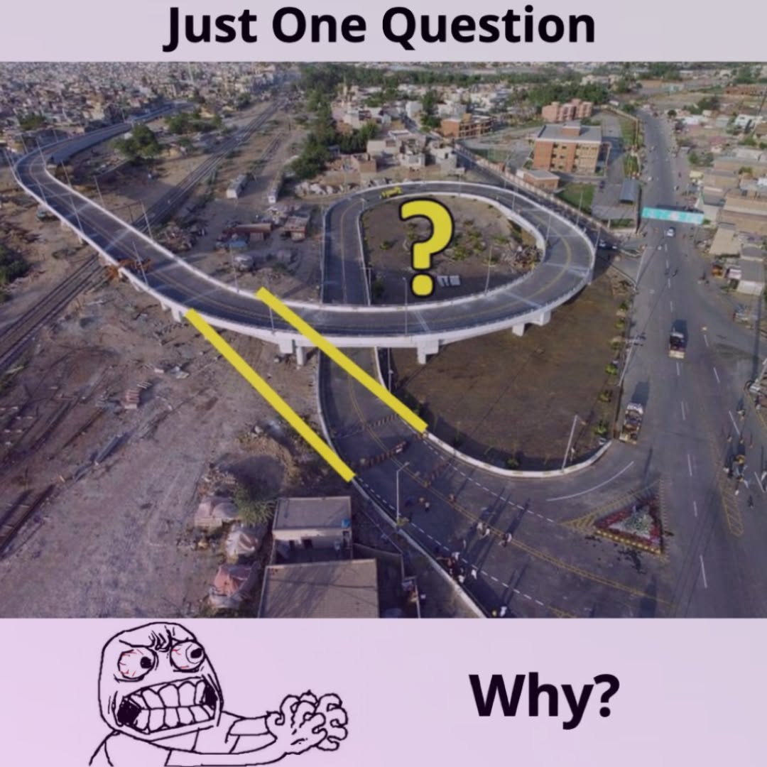
At first glance, this flyover looks like somebody drew the road with a ruler, changed their mind halfway through, and then kept going anyway. The flyover loop appears to take a huge detour when a much shorter straight connection seems to be sitting right there.
And honestly, that reaction makes sense. From above, the yellow “shortcut” looks so obvious that you might wonder why anyone would spend extra money building hundreds of feet of additional roadway.
But roads are not designed on a blank sheet of paper. That apparently empty space may hide property boundaries, rail tracks, drainage channels, buried utilities, elevation problems, traffic conflicts, or other restrictions that completely change the equation.
So before calling the design wasteful, there are a few things worth knowing.
The Straight Line May Not Be a Real Option
Look at a map and drawing a straight line is easy. Building that line in the real world is another story.
For instance, the direct route could cross privately owned land. Buying that property might mean lengthy negotiations, legal disputes, relocation costs, or years of delay. A slightly longer alignment that stays inside an existing transportation corridor can sometimes save a surprising amount of money.
There may also be buildings, parking areas, transmission lines, pipelines, drainage systems, or other infrastructure that is difficult to see in an aerial photograph.
Pro Tip: When a road seems to avoid a strangely open piece of land, don’t assume the land is available. “Empty” does not necessarily mean “free to build on.”
That Big Curve May Actually Be Safer
One of the biggest reasons for a looping ramp is simple: vehicles need room to turn.
A highway ramp designed for moving traffic cannot always make a tight turn just because that would save distance. As speed increases, drivers need a larger curve to make the movement comfortably and predictably.
A sharp bend also creates other headaches. Drivers have less time to see stopped vehicles, changing traffic conditions, or the end of the ramp. Large trucks and buses can have an even harder time handling tight curves.
So engineers may stretch the road into a larger arc. The result looks ridiculous on a satellite image, but from the driver’s seat, that same curve can feel much more natural.
In other words, the road may be taking a longer route because the vehicles are moving through the turn rather than simply drawing it.
Elevation Is a Bigger Problem Than It Looks
Here’s another detail that aerial photos hide: height.
A flyover has to climb from one level to another. That climb cannot simply happen instantly, and vehicles need a reasonable slope to make the transition safely and comfortably.
Imagine trying to reach the top of a building using a ramp that rises several floors in a very short distance. The ramp would become extremely steep. Cars would struggle, trucks would work harder, and the transition could become uncomfortable.
A longer road gives engineers more distance to gain the required height gradually.
That giant loop can therefore function like a long staircase for vehicles. It takes more space, but each section of roadway can maintain a manageable slope.
What About the Bridge Supports?
This is one of the easiest details to miss when looking at a photo.
An elevated road needs structural supports. Those columns cannot simply be placed wherever the designer wants. Engineers have to consider what is underneath the bridge and where foundations can safely be constructed.
If the direct route crosses an active road, railway, drainage channel, or another structure, placing supports there may be difficult or expensive.
A different alignment might allow the bridge to use more practical foundation locations while keeping important routes below open to traffic.
Sometimes the longer road is not about the pavement at all. It is about finding places where the structure underneath can actually be built.
The “Shortcut” Could Create a Traffic Nightmare
Here’s where things get particularly interesting.
The shortest connection is not automatically the fastest connection.
Suppose a straight ramp drops vehicles directly into a busy road. Now hundreds or thousands of cars may need to merge in the same small area. Drivers entering, exiting, changing lanes, and braking can all compete for the same piece of pavement.
That creates weaving, which can slow traffic and increase the chance of conflicts.
A looping ramp can separate those movements and give vehicles more room before they reach another traffic stream.
Yes, each individual driver travels farther. However, the entire intersection may work better because vehicles are not all fighting for the same few meters of roadway.
Why the Cheapest Road Isn’t Always the Shortest Road
This is probably the biggest misconception behind photos like this.
People naturally think more pavement means more money. Sometimes it does. But construction cost depends on much more than the number of meters of asphalt.
A straight route might require expensive land purchases, utility relocation, complicated bridge foundations, long structural spans, retaining walls, or major changes to existing roads.
Meanwhile, a longer curved route might use simpler construction methods and existing transportation land.
For example, imagine two options:
- Route A: Shorter, but requires moving several utilities and building complicated foundations.
- Route B: Longer, but uses available land and simpler supports.
Route B can look wasteful from the air while actually being the less expensive project.
There Could Be Drainage Problems Hiding Below
Water is another issue people rarely consider when judging road layouts.
Roads need drainage, particularly elevated structures and ramps exposed to heavy rain. Water has to move away from the pavement without flooding nearby roads, properties, or transportation corridors.
The surrounding terrain can therefore influence where a ramp goes.
A route that looks beautifully straight might send runoff toward a low point or require expensive drainage work. A curved alignment may fit the existing grades and drainage system more naturally.
How to Read the Photo Like an Engineer
Next time you see a strange road design online, don’t look only at the pavement. Look at everything surrounding it.
- Check for railways: A rail corridor can dramatically limit where a bridge can cross.
- Look for existing roads: The ramp may be designed around traffic that isn’t obvious from the main image.
- Look for property boundaries: Empty land may belong to someone else.
- Check the elevation: A flyover needs enough distance to climb gradually.
- Look for support columns: Their positions can reveal structural limitations.
- Watch the merge areas: A direct connection might create a dangerous traffic conflict.
- Notice drainage channels: Water management can dictate surprisingly large parts of a road project.
Once you start looking for these details, the strange shape often makes a little more sense.
Could the Loop Still Be Bad Design?
Absolutely. Not every unusual road deserves a free pass.
A poorly planned ramp can still waste land, add unnecessary travel distance, create confusing lane changes, or cause frustrating congestion.
The important point is that one photograph cannot prove whether the design is good or bad.
To judge it fairly, you’d want traffic counts, engineering drawings, property information, crash data, construction costs, and details about the surrounding infrastructure.
That’s a lot more information than a satellite image provides.
Why Drivers Sometimes Hate These Designs
Even when a loop makes engineering sense, drivers may still dislike it. That’s understandable.
People naturally prefer roads that feel direct. When you’re sitting in traffic and watching the destination appear just across the road, taking a long curved route can feel almost insulting.
Good signs and lane markings therefore matter. Drivers should have enough warning to understand where the ramp leads and which lane they need before reaching the merge.
Lighting, reflective signs, clear arrows, and sensible speed guidance can also make a complicated interchange much easier to use.
The Big Lesson: Shorter Doesn’t Always Mean Better
The next time you see a flyover that appears to take the longest possible route, pause before judging it.
The road may be avoiding private property. It may need a gentler curve. It may be climbing several meters in elevation. Its supports may have to avoid another highway or railway. Or the direct route may create a nasty merging problem.
Sometimes, of course, there may be a simpler explanation—and occasionally a project really can be improved. But the yellow line drawn across a photo doesn’t show the whole engineering problem.
The best road is not necessarily the shortest road. It is the one that balances safety, traffic flow, construction costs, available land, structural requirements, drainage, and long-term maintenance.
So that giant loop may look like a ridiculous detour from the sky. From the ground, however, it could be doing exactly what it was built to do: moving thousands of vehicles through a complicated space without forcing every problem into one straight line.
“`